


advertisements


News

Weather
Posted: Jan 14, 2022 3:09 PMUpdated: Jan 15, 2022 5:00 AM
UPDATE: 1-2 Inches of Snow Possible for Washington, Nowata and Eastern Osage Counties


Tom Davis
According to the National Weather Service, a strong storm system will bring accumulating snowfall and strong winds to the area starting late tonight.
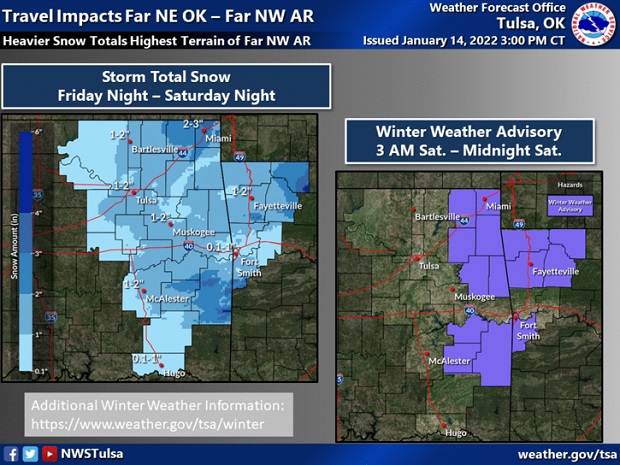
Rain will quickly transition to a rain/snow mix or all snow by Saturday morning across much of eastern Oklahoma and northwestern Arkansas which will lead to at least minor accumulations of snowfall for most.
The 4pm Friday forecast shows Washington, Nowata and Osage Counties under a Wind advisory now until 5pm Saturday, January 15. The estimated snowfall for Washington, Nowata and Eastern Osage Counties has been upped from about and inch to 1-2 inches.
Snow combined with gusty winds of 25 to 40 miles per hour can create brief whiteout conditions. Some blowing and drifting of snow across mainly east-west roadways will be possible. An expansion of the current winter weather advisory is possible if confidence in impacts improves.
Use caution if you are traveling across eastern Oklahoma and northwestern Arkansas late tonight into Saturday. The highest snowfall totals are currently expected across far northeast Oklahoma into far northwest Arkansas, especially for locations within the higher terrain of far northwest Arkansas where several inches of snow are possible.
« Back to News