


News

Cherokee Nation
Posted: Sep 25, 2020 9:32 AMUpdated: Sep 25, 2020 9:32 AM
Cherokee Reservation Visible on Google Maps

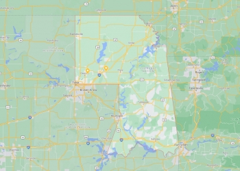
The Cherokee Nation’s reservation boundaries are now mapped on Google Maps.
In a statement, Cherokee Nation Principal Chief Chuck Hoskin Jr. said, “After the monumental US Supreme Court ruling in McGirt v Oklahoma, we’ve had many questions about our reservation boundaries, which always existed on paper maps. Now that our reservation is labeled on Google Maps, it’s easy for people around the world to search and see our reservation boundaries.
The Cherokee Nation reservation boundaries include 7,000 miles in northeastern Oklahoma.
Raleigh Seamster, program manager for Google Maps said, "Google Maps aims to provide the freshest, most accurate map possible. In response to July's Supreme Court decision, we worked to evaluate authoritative data and then used this information to add labels and borders for the Muscogee (Creek) Nation, Cherokee, Chickasaw, Choctaw, and Seminole reservations to Google Maps. These reservations are now viewable and searchable on Google Maps.”
Cherokee Nation citizen Joseph Erb provided feedback about the reservation mapping project, which includes mapping for all Five Civilized Tribes. Erb said, “It is an exciting step forward to be included on the map. This is a visual reminder that our nation is still here and a contemporary Indigenous nation of Continent.”
The link to the Cherokee Nation reservation on Google Maps can be found here.
« Back to News